The East African Rift Zone represents a profound example of the dynamic nature of Earth’s crust, a process that began with the breakup of the supercontinent Pangea around 200 to 175 million years ago. This breakup was driven by rifting, the tearing apart of the continental crust, propelled by large-scale lithospheric plate motions. Current computer models suggest that mantle upwelling, involving the rise of hot magma plumes from the deep mantle, plays a crucial role in this process. As these plumes near the surface, they bulge, warp, and partially melt the overlying crust, leading to its weakening. The cooling margins of the plumes then start sinking, pulling the crust apart.
This rifting process was responsible for the gradual disintegration of Pangea into smaller landmasses over approximately 150 million years. However, the spherical nature of our planet means that the drifting continents eventually start colliding anew, as seen in the formation of mountain ranges like the Himalayas and the Alps.
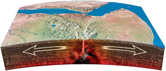
In the case of the East African Rift Zone, the rifting initiated around 30 million years ago under the eastern edge of the African continent. As the crust weakened and thinned, it began to split along a 3,700-mile-long (6,000-kilometer) valley stretching from Ethiopia to Mozambique. This geological activity is marked by numerous earthquakes and volcanic eruptions, evidencing the intense heat and energy driving the separation of the African plate.
Today, the East African Rift Zone is the largest seismically active rift system on Earth, with the crust spreading at about 0.24–0.28 inches (6–7 millimeters) per year. Should this movement continue, it is projected that in around 10 million years, Africa will divide into two new tectonic plates – the Somali plate to the east and the Nubian plate to the west – potentially creating a new ocean basin between them. This ongoing event is a striking demonstration of the ever-changing nature of Earth’s geology.