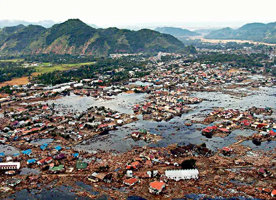
The 2004 Sumatran Earthquake and Tsunami stands as one of the most devastating natural disasters in recent history. On December 26, 2004, a massive magnitude 9.1 earthquake struck beneath the Indian Ocean near Sumatra, triggering a catastrophic tsunami. This seismic event, part of the volatile Pacific Ring of Fire, led to a colossal crustal rupture extending approximately 250 miles in length and 60 miles in width. The earthquake’s force uplifted the seafloor by about 6 feet, displacing an enormous volume of water and setting off the deadly tsunami.
Due to the proximity of the earthquake’s epicenter to the coast, communities in Sumatra and Thailand had virtually no warning. The tsunami waves, magnifying in height as they neared shallower coastal regions, reached staggering heights of up to 100 feet in some areas of Indonesia. This immense wave caused widespread destruction along the coasts of nations bordering the Indian Ocean. Tragically, the lack of sufficient tsunami warning systems and evacuation plans contributed to the staggering death toll of approximately 280,000 people, marking this as the deadliest tsunami in recorded history.
The 2004 Sumatran tsunami underscores the critical importance of understanding seismic activity and enhancing global tsunami warning systems. It serves as a grim reminder of the destructive power of natural forces and the urgent need for preparedness and effective communication in coastal regions.